

View of wetland habitat, Woodwalton Fen NNR, Cambridgeshire, UK - Mark Hamblin/2020VISION
Last of the Meres
Update April 2026: Work on the new wetland is now complete. However, paths remain closed to allow time for them to re-grass after all the heavy machinery work. Thank you for your patience.
Update November 2024: From Friday 15th November we are undertaking ground and engineering works in the New Decoy area. These exciting works are part of our 5-year National Lottery Heritage Fund project Peatland Progress – A New Vision for the Fens. We are creating a variety of new wetland habitats to enhance the value of restored land for wildlife and protect peat soils; and we are improving visitor access by creating a new parking area which is central to the conservation area.
This means East sections of both The Last of the Meres and Dragonfly Trails are closed while construction is underway. Public access to these areas is not permitted from 15th November until further notice for your safety. Please follow the signposted diversions. You'll notice a loop is still possible on the Dragonfly Trail, it's just a bit shorter. Diversion maps are located at New Decoy Information Point car park and Northern Loop car park.
We do apologise for any inconvenience but look forward to reopening access for you to enjoy these new wetlands and the wildlife they'll attract in due course. Thank you for your understanding and patience.
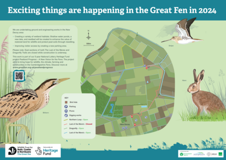
New Decoy trail map with diversions
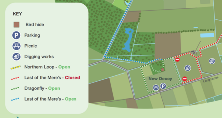
New Decoy Dragonfly trail diversion closeup
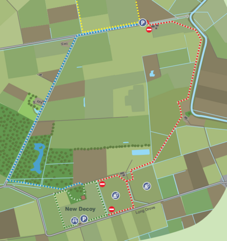
Last of the Mere's trail closure closeup
Last of the Meres
The Last of the Meres trail is a circular walk connecting the northern parts of the Great Fen. It extends from newly restored areas at New Decoy Farm to the historic site of Engine Farm, through to the woodland of Holme Fen and back via the old Holme to Ramsey railway line. The route also crosses the former site of Whittlesey Mere, the largest lowland lake south of the Lake District before it was drained in 1851.
The Route
The route follows new paths in the northern section of the Great Fen project area. It is 6.5 miles in length and is a circular walk, taking approximately 4 hours to complete. There are way markers for the Last of the Meres trail which lead you in an anticlockwise direction around the trail. Please report any footpath problems to the Great Fen team via info@greatfen.org.uk
Please note that at Engine Farm, where there is an automated locking gate on the bridge. This allows passage across the dyke from 8am to 4pm in winter and 8am - 8pm in summer, so please leave yourself plenty of time and take into account the daylight variation with the year's seasonal changes.
The map below gives a rough outline of the route, marked in red with start & finish identified by red circle. For a more detailed route we suggest you refer to Ordnance Survey Explorer Map 227.

Reproduced by permission of Ordnance Survey on behalf of HMSO. © Crown Copyright. All rights reserved.

Holme Fen - Sarah Lambert


