
Holding, in your own hand, a piece of well-preserved reed that grew thousands of years ago certainly brings the past alive, connecting you with a very different environment that has now disappeared. Peat is an amazing thing: it is a record of life, of habitats and of landscapes and forms a backdrop to the story of the human occupation of fenland. This handful of ancient reedbed, together with seeds of wetland plants such as bogbean hidden amongst the stems, has been preserved under the water table where a lack of oxygen has prevented its decomposition.
Time Travelling in the Fens

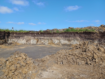
Dr Steve Boreham, members of CGS and Wildlife Trust staff with the core taken in June 2025 from New Decoy, where new wetland habitats are being created. Credit: Henry Stanier.
Chris Donnelly of the Cambridgeshire Geological Society takes us on a journey underground and back in time to the Neolithic fenland swamp!

Bogbean seed in wood peat, found at Engine Farm, 2022. Credit: Chris Donnelly
The peat core that we are examining has reached 1.7 m deep so far. We’ve seen a mixture of reed peat, wood peat (containing quite large chunks of wood) and detritus mud from a peatland pool, beneath an approx. 40 cm covering of degraded peat (the latter forming the soil). Nearby, towards Holme Fen, wood from reed peat found at 2 m depth has been dated to about 5,500 years ago, the mid Neolithic. At this time, the southern fenland basin would have been filled by a huge freshwater ‘swamp’. At Rymes Reedbed, peat taken from a borehole was dated at over 7,000 years old, so Mesolithic in age. Although we don’t know the exact age of the peat we have found today, it is amazing to think that we are able to see plants preserved for thousands of years.
By 2.1 m we have reached a grey, partly sandy and silty clay with some gravel. This is likely to be a periglacial deposit formed from a mixture of eroded bedrock and channel deposits in the tundra-like environment of the later stages of the last glaciation. We finally reach the (Jurassic) Oxford Clay bedrock at 2.25 m – you know you’ve hit it when it suddenly gets a lot tougher to turn the auger! We use three metre-long pieces of guttering to hold the material extracted, in strict order and marking the depths along the side, a handy way to produce a temporary display showing thousands of years of history. (There is one on display in the classroom at Ramsey Heights if you'd like a closer look.)

Freshly dug part of the core, still in the auger; the change from detritus mud (fen peat) to soft, silty clay (periglacial) is at about 2 m. New Decoy, September 2025. Credit: Chris Donnelly.

Dr Steve Boreham, members of CGS and Wildlife Trust staff with the core taken in June 2025 from New Decoy, where new wetland habitats are being created. Credit: Henry Stanier.
Dipwells and water levels
Today’s peat core (September 2025) is one of several that have been taken in the Great Fen in recent years. In order to manage the hydrology, the water levels beneath the ground need monitoring and this involves installing a row (transect) of dipwells across the area being studied. Each dipwell consists of a 2-3 metre-long series of tubes, buried in the ground, housing a sensor to record the water level relative to the surface. One of the major factors affecting the water levels here is the complex geology, so when the dipwells are installed, the material removed (as a core) is studied to provide information that helps interpret the hydrological data.
Comparing cores from various locations helps to inform the design of the restoration land, for example, areas with significant gravel deposits cause water to seep away so would not be ideal for rewetting.
A new water storage pool being created at New Decoy, showing the geological layers. Understanding the geology of the land, ensures wetland restoration work can be undertaken in the most appropriate places. Credit: Lorna Parker
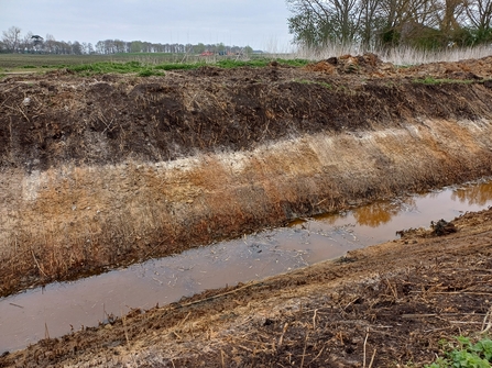
Colourful layers visible in newly profiled ditches. Credit: Lorna Parker
The Great Fen's unique geology
Part of the Great Fen has been designated as a Local Geological Site due to its unique combination of geological features. The most important of these are its Holocene deposits (formed since the last glaciation, which ended about 11,000 years ago), known, geologically, as part of the ‘Fenland Formation’. The Cambridgeshire Geological Society (CGS) has, therefore, been helping with the cores alongside Dr Steve Boreham, a specialist in the geology and associated ecology of fenland; his expertise enables him to identify the material found and describe the local environment at the time of its deposition. Each core tells a slightly different story, showing how conditions can vary over short distances at any one time, and this explains the complex nature of the Great Fen today.
Cores at Engine Farm show that there is calcareous marl above the peat, this being the remains of the lake bed of Whittlesea Mere. The mere formed about two thousand years ago during the Iron Age when a rise in sea-level caused backing up of freshwater around the edges of fenland. Due to its mineral nature, the marl does not shrink as much as the peat when dried, so this part of Whittlesea Mere is now higher than the surrounding peat. Other studies have recorded smaller areas of it overlying the peat at Rymes Reedbed, the signature of a much older lake, Trundle Mere.
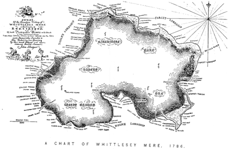
Whittlesea Mere
Looking north over the area of lake marl, all that remains of Whittlesea Mere, which formed about 2,000 years ago and lasted until the drainage of the mid 1800s. Credit: Chris Donnelly.
When the sea reached the east of the Great Fen
Some of the most interesting cores we have looked at are those that show an interruption in the formation of peat, seen by a layer of silty clay not far beneath the surface.
At Chalderbeach Farm, on the eastern side of the Great Fen, it appeared in one of our cores at 70 cm deep and was 35 cm thick, with only soil and degraded peat above but about 2 m of preserved peat below it. A similar clay was found at 1.5 m depth at Engine Farm, underneath lake marl and (Upper, Nordelph) peat, and in other studies it was found at 70 cm deep at Rymes Reedbed where it was dated to the Early Bronze Age (about 4,000 years ago). This fits with the known sea incursion of the fenland that started in the late Neolithic and lasted a few hundred years, into the Bronze Age. Tidal mudflats and saltmarsh covered much of the lower land in the southern fen basin at one point or another.
Significantly, these tidal conditions did not reach the far west of the Great Fen and did not interrupt the formation of peat in the freshwater marshes here: the thickest sequence of peat in the Great Fen (and the southern fenland) is found in the Holme Fen area. Due to the disappearance of the overlying peat, the tidal deposits are at the surface in the east, at parts of Stokes Farm and Chalderbeach, where they create slightly undulating land compared to the flatter surface of the peat areas.
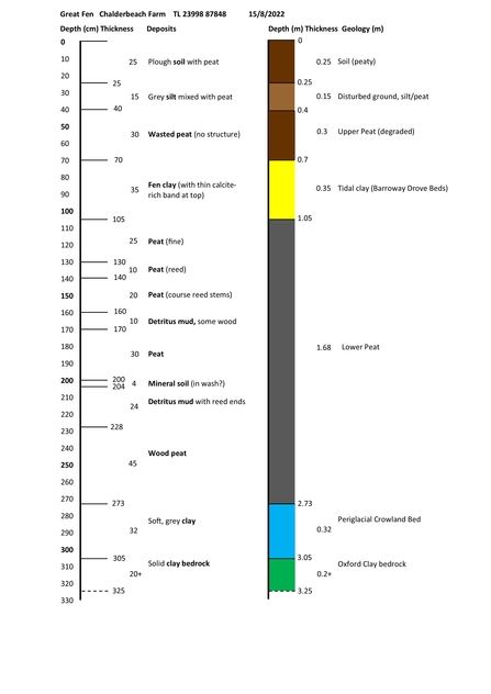
Log of a peat core from Chalderbeach Farm, showing (in yellow) the tidal clay lying beneath a thin layer of degraded peat and over a significant amount of buried peat.
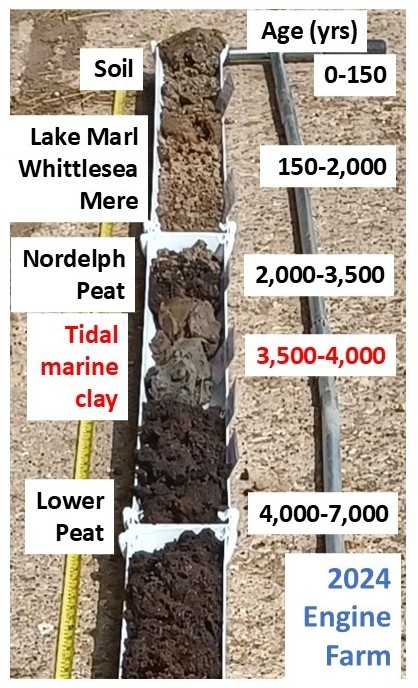
Top two metres of core from Engine Farm 2024 showing the different layers and their likely age. Credit: Chris Donnelly.

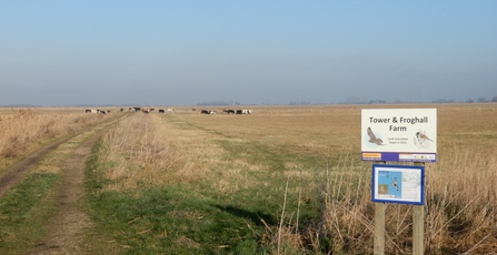
Tower hide at Trundle Mere, Rhymes Reedbed
4,000 years ago, the view east from Rymes Reedbed would have featured tidal mudflats and saltmarsh, as sea levels rose and spread this far inland.
Seeing a peat core for the first time, people are often surprised by the complexity of the ‘peat’; it can contain detritus mud from pools, thin layers of buried soil with rootlets, reed peat, wood peat, sedge peat and quite large, solid pieces of wood. We occasionally find sphagnum moss peat in cores at various sites and there are deep layers of it (the deepest known in the southern fen basin) to the west of Whittlesea Mere. These are the remains of acidic raised bogs, formed when the peat build up was high enough above the water table to remove it from the influence of the calcareous ground water. These raised bogs survived until the draining of the mere and are the reason the peat shrinkage in the Holme Fen area was so dramatic.

Ancient birch wood found in peat. Credit: Lorna Parker
The importance of peat
The peat deposits of fenland are not only of great heritage value (both natural and cultural) but their preservation is now key to reducing carbon loss to the atmosphere. In the Fens generally, it is important to distinguish between degraded peat at the surface (forming the soil) and the preserved peat beneath (considered part of the geology). The erosion of soil at the surface exposes the underlying peat; this is not only a concern in areas where there are ‘peat soils’ but also where there are significant buried peat deposits under silt or clay soils.
Peat cores reveal essential geological information to help guide future nature conservation and they also provide a window into the complex and fascinating environments of the past. If you want to learn more, look out for the Wildlife Training Workshop on the Geology of the Great Fen, with Dr Steve Boreham, next year.

Cambridgeshire Geological Society logo

By Henry Stanier

Roddons (fossilised sand and silt filled tidal creek systems) visible in the soil at Thorney. Credit: Google Earth