

Whittlesea Mere
Whittlesea Mere
The Great Fen includes a huge area that was once the largest lake in lowland England. In geological terms it did not exist for very long - some 2300 years - but it had a big influence on the culture and heritage of the fens and this part of the country.
Early history

Early Bronze Age flanged axe head, found when the Mere was drained. From Peterborough Museum.
Formation of the Mere
It is thought that Whittlesea Mere formed from about 500 BC, when silt was deposited by the rivers Nene and Welland and water backed up because it couldn’t flow away freely towards the Wash. A series of lagoons formed and water plants, sedges, reeds and mosses began to grow. Wetter and drier periods occurred and over the centuries the plants decomposed and turned into peat. Whittlesea Mere formed as a shallow lake alongside a river bank on the north side and with a peat bog on the south.
The Mere was at one point six miles across, the largest lake in lowland England. But it was very shallow, only from two to seven feet deep. Its area in 1786 was 1570 acres, but this varied seasonally. The Mere was at or below sea level and so was very difficult to drain, which is why it survived until 1851.
The bottom of the Mere was covered with a thick layer of white shell marl (decomposed remains of freshwater shells). Below this are alternating layers of clay and peat, showing that conditions had changed over the long periods of time, from salt to freshwater conditions and back again.
The influence of the monasteries
The Romans were the earliest people known to have dug a dyke in Fenland, the Car Dyke, for drainage and transport of grain to Roman forts. The earliest reference to Whittlesea Mere is in 664AD, when ownership was transferred from the Crown (possibly the Mercian king Wulphere) to Medehampstede Abbey, now Peterborough, which had been established by the Saxons in about 657. Other monastic sites followed at Thorney in 662, Ely in 673 and at Crowland by the Saxon saint Guthlac in 716. Chatteris and Ramsey were established later. In about 1020, in the reign of the Danish king Canute or Cnut, some of his family and servants were caught in a storm on the Mere and nearly drowned. Cnut caused a dyke to be dug from Bodsey near Ramsey across the marshes to Pondersbridge and on to Peterborough. The dyke may also have been used for moving building stone.

Ramsey Abbey censer and incense boat © Victoria and Albert Museum, London. These magnificent objects came to light when the Mere was drained in the 19th century.
The Abbeys at Ramsey, Sawtry and Peterborough managed the fishing grounds on Whittlesey Mere. It was divided into 'boatgates' (one boat, three men and specific size of nets) and licences for fishing were sold, giving the Abbeys a valuable income. From the 13th century onwards the Abbeys also caused the first dykes to be dug in the area using the labour of people living on Abbey lands. After the dissolution of the monasteries in 1534, Abbey lands were sold off to many different landowners. The Cromwell family bought Ramsey Abbey and its lands which included much of the Mere.
Whittlesea Mere was already very popular for pleasure excursions by boat. In 1697 Celia Fiennes, daughter of a Cromwellian general, passed by the Mere on one of her journeys: she recorded that she
‘came in sight of a great water, looked like some sea it being so high and of great length. It was 3 miles broad and six long. In the midst there is a little island where a great store of wildfowle breeds; when you enter the mouth of the Mere it looks formidable and its often very dangerous by reason of sudden winds that rise like Hurricanes, but at other times people boat it round the Mere with pleasure, there is abundance of good fish in it.’
The Mere at that time was very shallow, only 5-6 feet deep. By the early 19th century it had become even shallower, often only 2 feet deep with more vegetation growing in it due to improved drainage in other parts of the Fenland. It had become ‘a nuisance’ and in 1844 the Middle Level Act gave parliamentary powers for the drainage of Whittlesea Mere and the surrounding lands.
Natural history and resources
All the early sources describe the extreme richness of the Whittlesea Mere area, in particular the waterbirds and fishes, from which many of the local people made their living. The reed and sedge harvests provided another source of income. From about the early 1800s the natural fauna and flora began to decline as a result of the gradual drying out of the whole area. Many species were in terminal decline before the Mere was drained.
Early botanists valued the area for its diversity of plants. The Victorian enthusiasm for collecting wild plants and insects also had a big impact. Local people made money by sending trunkfuls of specimens to London collectors via the new railway from Holme station. Specialist plant and animal species became extinct after the drainage of the Mere, as a result of the habitat changes and also from over-collecting.
Earning a Living

The richness of the Mere's natural resources supported many local families and villages, providing different foods all through the year … if you could catch it! Families turned their hands to many different jobs, the children working alongside their parents from quite a young age.
Peat cutting
Peat cutting or Turf digging provided fuel for heating and cooking at home, and it was also a product that could be sold. Much of the wet land to the south of the Mere was originally a (sphagnum) bog. Local people would rent a small area, dig the peat as blocks and dry it, then use some themselves and sell the rest. Most of the work was carried out in the drier months of the year, when other work wasn’t available.
Gathering reed and sedge
The Mere was surrounded by great beds of reed and sedge, and this provided another good source of income. Reeds were cut from about Christmas up to March and were sold in bundles for thatching and in plastering ceilings and floors. Merchants coming into the area with goods from the Midlands and other parts would take a load of reeds back with them. Sedge was cut every three years and was also used for thatching and for animal bedding. The woolly heads of Bulrushes were stripped off and used to stuff bedding.
Fishing
Fish, especially eels, were so abundant that they were used as a currency, and were used to pay rent money to the Abbeys. Whittlesea Mere held pike, perch, carp, eel, bream, chub, roach and dace . The fish were caught by licensed fishermen using nets of specified sizes. Fishing rights (see ‘boatgates’) were carefully guarded and managed. The adjoining parish of Glatton with Holme held the right of testing fisherman’s nets at a special court in Holme: if the bailiff found that the nets had too small a mesh he had the right to burn them. When the Mere was finally being drained nets were dragged for weeks and tons of fish were taken out by horse and cart.

Wildfowling
The Mere abounded in wildfowl especially water birds. Local people were expert in catching them using nets, guns and a decoy pond. Birds now rare such as Bitterns were plentiful and gentlemen came from far away to enjoy shooting parties with local landowners, and with local people acting as guides. The birds were transported to local towns and markets for sale, and once the railway arrived fowl were sent by trunkloads to London. As the Mere dried out all these birds disappeared.

"Whittlesea mere was also a favourite resort of the wild-fowl hunter. For this purpose a sledge on bone-runners.. was required. In front of this sledge a fence of upright reeds was arranged which partially concealed the projecting muzzle of a long duck-gun carrying a heavy charge of shot. Kneeling in the hinder part fof the sledge, and punting himself along with two iron-shod sticks, the sportsman was eanbled to approach to within a short distance of the islands of sedge, which were to be found near the shores of the Mere, and were frequented by flocks of duck, teal, widgeon and other wild fowl."
(J M Heathcote + C. G Tebbutt. Skating, 1892.)
Agriculture
The land surrounding the Mere was divided up between the surrounding villages so that each had some higher cultivated land, an area of rough grazing and fenland, and an area of the huge reed beds surrounding the Mere. The land nearest the Mere, especially to the south, could often only be used as grazing in the summer months – it was just too wet for anything else. Described as ‘fen pasture’, large numbers of cattle and sheep were fattened there. West of the Mere, some land was cleared and cultivated for a few years and then the fields were allowed to return to rough grassland. Local people might either rent a piece of land to raise a few animals themselves if they could afford it, or work for a larger landowner.
Whittlesea Mere - Daily Life
Social and economic conditions, population growth
Although there were plenty of ways to make a living, life was harsh and the population was fairly thinly scattered up until the 1800s. Census returns show the biggest increase being between 1841 and 1851. Many people who had made their living from the natural riches of the Mere bitterly resented its drainage, and the disappearance of their way of life. More people moved into the area as drained land became available for farming, local parishes were split and the new parishes of Holme and Ramsey St Marys established. The villages expanded, but many of the cottages were very damp and flooded in winter and the fen droves were nearly impassable in wet weather. Families could be cut off for months at a time and reaching help or a doctor was very difficult.
The population of the area dropped in the 1880s as a result of the agricultural depression. Agricultural labourers, if they stayed in the area, turned their hands to other local work such as brick-making. But by the beginning of the 20th century, population numbers had recovered.
Health, mosquitoes and ague
Mosquitoes thrived in the damp fens and carried a form of malaria known as ague (pronounced ay-gu). This produced fits of shivering and intense pain in the limbs. Once infected a person could suffer from fits of ague and fever for many years and it shortened their lives. Fen people drank brandy and chewed or drank opium as a cordial to try and protect themselves from the disease but opium became a habit as well as a necessity. Local-born people had some resistance to ague, but fen-men marrying girls from other areas often lost their wives to ague and other illnesses.
Many children died young, not only from childhood illnesses but from drowning in the fen ditches, from poor water supplies and sanitation and from the difficulty of reaching (and affording) medical help.
Recreation and sport
Whittlesea Mere was famous for its yachting, boat races, regattas, fishing and fowling and also its skating competitions and ice fairs in harsh winters, when everyone waited for the ice to form. Skating had been a local pastime for generations, using bone or metal skates, and by the 1700’s local champions competed in keenly fought races for prizes of goods or money. Ice fairs were held too, ‘stalls and booths were erected, chestnuts roasted and bands of music played’. In 1840 a thousand acres of water was frozen over and 6000 people gathered at the Mere to skate and watch races run over a two-mile-long course.
"Whittlesea Mere Regatta, June 16 1841, Off Swerve Point"
Assuming Swerve (or Swere) point is the promontory on the right hand side of the picture and there is a southwesterly wind, this picture would show the view looking east from the western shore. i.e. this is the equivalent view to what can seen from Trundle Mere Lookout today!
Transport
Whittlesea Mere was important in the local area as a way of moving heavy and bulky goods, such as bricks, peat turves and loads of reed and sedge. The Mere connected to at least three main waterways on the north and eastern sides, so other parts of Fenland could easily be reached. Horse-drawn lighters were used on the waterways, but no doubt they put up a sail to cross the Mere, or were perhaps "spritted" (poled) across, as the Mere was shallow. Lighters were built in a yard at Stanground, about 4 miles north of the Mere near Peterborough.
The following picture and text have been copied, with permission, from the Fenland Lighter Project website.
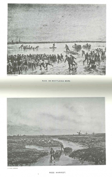
Photo : The Great Fen - Whittlesey Mere
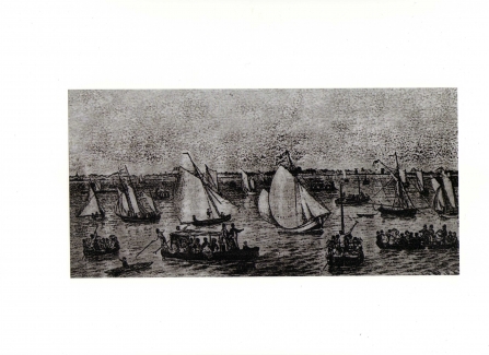
Photo : The Great Fen - Whittlesey Mere


